Tuesday, March 29, 2011

Sacred Rocks Reserve in Boulevard, California

Boulevard, California has a population of less than 1,500 and the locals affix "Where The Hell is Boulevard?" stickers to their vehicles.  It's about 30 miles west of El Centro and is a stone's throw from the Mexican border. Interestingly, most everything, billboards and the like, are in English, not Spanish.

Sacred Rock Reserve is a Bureau of Land Management 163 acre parcel of rocky, hilly land.  At Sacred Rocks Reserve Campground, campers can hike, rock climb and see a 500 year old Live Oak tree.  Formerly known as Outdoor World RV Park, the area is fully natural and even gets all the water used in the campground (including ice sold at the camp store) from an underground aquifer.

We stayed two nights here in route to San Diego.  It is quiet and somewhat dusty, but the soil is sandy and easy for Lexie to manuver. The three of us hiked a short distance inside the reserve, to an area known as Look Out Rocks, where we viewed surrounding rocky hillsides. 

The nights are cool (40's) and the days are warm (70's).
Entrance to Sacred Rocks Reserve

Our campsite among the Live Oak trees.

Lexie is taking in the view from Look Out Rock

Lexie rock climbingat Look Out Rock

Wayne and Lexie challenging one another to make the first move.

Mom finally takes charge!
Leaving here, we'll move on to San Diego. We're having a wonderful time, hardly ever know the date, much less the time of day and enjoying retirement more than we ever even imagined! 

California Here We Come!

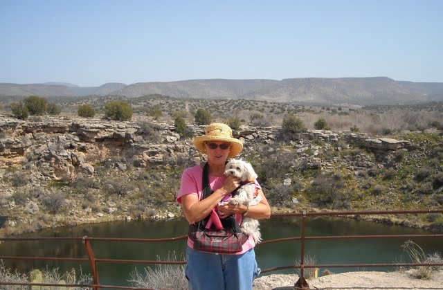
After three months, (December 22 - March 27) we're really leaving beautiful Arizona. I've had a love-hate relationship with the desert; on the one hand, it's so dry and there's no shade. But on the other hand, I've learned to see desert life, to appreciate the beauty of the terraine and rocky mountains.

But on this day, March 28 (Cam's birthday), we leave the Colorado River Oasis Campground, cross the river into California.  Interestingly with the state's financial crisis, it's the only state line I've ever seen that staffs a 'state line' to ask if anyone is bringing fruit into the state.  But then, everything's different in California... remember OJ Simpson. I took a picture of this oddity but somehow managed to delete it. Drat.

Crossing the river I took this photo from the bridge. It looks across the Colorado River into the campground we just left (to the left of the photo). 


We traveled west on I-10 less than 10 miles to California Highway 78 South. There's no denying we're in the heart of agriculture country and the fields are enormous -- reaching farther sometimes than I can see.
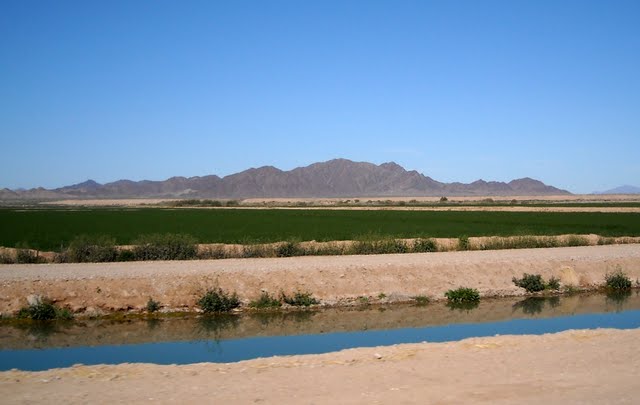
A sample of the view along CA78.  
Bright blue sky, mountainous backdrop and a crop field.  I think it's part of the Chocolate Mountain range.
The canal in the forground contains water diverted from the Colorado River.
Along the route we're taking, the agricultural land stops and we re-enter desert which seems to be in bloom now.  One of my favorite of the desert plants is the Ocotillo which has long slender thorny spikes topped with bright orange plumes. 
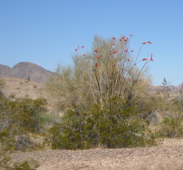
This Ocotillo is actually behind a bushy plant.
The blooming spikes can be seen atop the spikes.
There is "little to nothing" in the way of towns along this road but there are plenty of trashy dwellings.  Some were photo-worthy, but I didn't take any picutres.

Along the road we saw, at a distance, a desert mining operation of some sort. There were "Danger -- Keep Out" signs posted on the 10' chain link fence topped with razor wire. Looking at the map later we find it was probably Mesquite Mine, but we really don't know.  Wonder what that was all about. 

A few miles down the road, on the horizon we could see what looked like a bright "peachy" colored mound that we assumed was some more man-made mining result but as we drew closer, we saw we had come upon the Imperial Sand Dunes.  Neither of us had ever seen real sand dunes -- except in the movies.  What a treat.  I took a dozen pictures from the coach window and these are the best of the lot.
At this point we realized that what we had been seeing for several miles to be SAND DUNES!

Looks like lots of people come to the dunes.  We call these people "desert rats".


This pictures gives a good idea of the enormity of the Imperial Sand Dunes.  
There are four ATV's here.


Coming out of the dunes into the Imperial Valley.
About 30 miles outside Brawley, California, we came upon agriculture again in this area known as the Imperial Valley.  There are huge ranches here and cattle pens holding more cattle than I'd ever seen.  There were thousands of young cows in each large pen and we passed several pens.

At El Centro we saw another "first" for us.  A truckload of carrots.  Yes... carrots.  A double load.  Take a look and remember ... these are individual CARROTS!
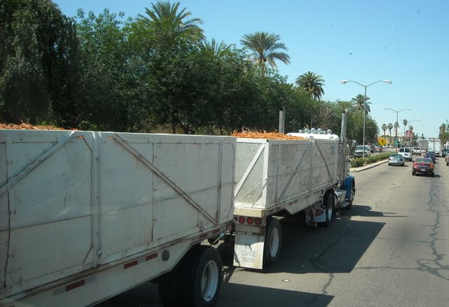
A double load of CARROTS!
At El Centro we took I-8 west and would soon begin a strech of highway that would take us from sea level to 3000 feet in a span of a few miles going up the southern tip of the Vallecito Mountains.  Another bright idea for the state of California: every mile marker has a telephone and a water barrel marked "Radiator Water" for travelers to stop and add to their vehicle radiator.  Gee whiz -- does anybody really need that?

Anyway, these mountains are clusters of HUGE smooth rocks.  The smaller of these rocks are the size of a car -- the largest are the size of our motorhome.  We've never seen anything like this either! 


What an exciting day of travel!  We arrived at Boulevard by about 3 p.m. where we'll be within a mile or two of the Mexican border. 

Sunday, March 27, 2011

Camping On The Bank of The Colorado River

For a few days, we're staying at Colorado River Oasis RV Resort in Ehrenberg, Arizona.  The Arizona / California state line follows the river.  Our campsite is steps away from the river and is pretty nice.  Ehrenberg really isn't a town at all, just an interstate exit, gas, food and a few campgrounds.  The first town inside California, Blythe, is a dreadful little place brimming with motels (can't imagine why) and is overpopulated with panhandlers. We had to go over to get to the nearest grocery store. 

Campground entry

It's not a bad campground -- all gravel but it does have some trees and a heated pool.

Note the nice little concrete "doggie sidewalk" we've come to appreciate.
Our motorcoach isn't in this picture. 

We have a little tree to shade our patio on the hot afternoons.
It seems all the campgrounds in Arizona are gravel. It's better than dirt/sand.
On this day I groomed (clipped) Lexie for the first time and didn't do too bad if I do say so myself.
As a reward, we let her gnaw on her cow's knee bone. That's it in front of her.
Directly across the road from our campground is an old pioneer cemetery that intrigued us so we stepped over to take a look.  It dates back to the 1800's and is the graveyard of many unknown pioneers -- but some graves have names.  No stones, just a few wooden nameplates held in place by rocks. 


Wayne is in his element in an old cemetery.

This blooming prickly pear cactus was the prettiest one I've seen.
It was in the cemetery.
The daytime temperatures are probably in the low 80's, usually with a pretty brisk breeze.  A walk at night requires a sweatshirt. Most days are clear and bright.  80 degrees here is much more pleasant than in the deep south due to the lack of humidity. 

We plan to have Mona's chassis lubed on Monday at a nearby service provider; then we'll move on toward California where we know we're going to pay more for EVERYTHING.

Saturday, March 26, 2011

Leaving Arizona...

The Camp Verde campground was nice but had no "doggie sidewalk" so Lexie had to walk on the sharp stones in the roadway. On Monday, rain moved in, was followed by really cool weather so we decided to backtrack south and move on toward San Diego, California. Leaving the campground, we were excited to see snow atop all the surrounding mountains. 

We exited I-17 at Cordes Junction and took AZ 69 to Prescot Valley where we found another really nice town. Our intention was to stay on that highway until we reached Wickenburg, Arizona where we expected to stay overnight or for a few days.  However, a road detour took us off the planned path and onto a county road (#10, I think) through another part of Precott National Forest where we drove through the most snow we've seen as the road elevation reached upward to 5,000 feet. 


After a few miles, we drove out of the snow and then through the towns of Iron Springs, Skull Valley and then Kirkland.  Along the way, we saw more beautiful rocky formations and then drove carefully along a mountainside that held a beautiful view far off into the distant desert flats. 


You can see the roadway in front of us.
In the desert valley below, you can see the towns ahead of us. 
This view probably covers some 40 miles.
By 2 pm we arrivedat Wickenburg.  The town was beautiful and there were tall trees in some parts.  New road construction caused our gps some confusion, but we recovered and entered the target campground only to find it was filled to capacity and there were no more in the area that appealed to us.  We both regretted not getting the chance to see more of Wickenburg, but we'd have to move on as we were tired and needed to get settled for the night. 

Highway 60 connects Wickenburg to Quartzsite and I-10 so we continued west through Aguila and Wenden before reaching Salone, where we would stay overnight at Desert Vista RV Resort -- which certainly was NOT.  It was another gravel pit, this time encircled by a chain link fence without a single tree. Our "site" held a big 4-yard garbage dumpster too! Most of the patrons here are "desert rats" with 4-wheel ATV's and they spend their days hurling themselves through the desert on any of the 256 trails I'm told are in the area.  The evenings are spent discussing the ATV speed, condition, operation and the lies of the day's drive.  Folks, there's something for everyone out here.   I did not take pictures here but probably should have...

We stayed overnight and left the following morning, going again through Quartzsite which we find to be most unimpressive.  I suppose the giant RV show changes the town but in mid-March, it's just not much.  We filled the coach with fuel as we've heard diesel in California is now well over $4 per gallon.  At Arizona's Exit #1, we stopped again to have Mona's oil changed.   By the time we got it all completed we'd spent most of the day and opted to stay at one of the local campgrounds.  We're at Colorado River Oasis in Ehrenberg, Arizona.  The campground is on the Colorado River and California is just on the other side.

Wednesday, March 23, 2011

Montezuma Well, Fort Verde, Coconino Forest, Red Rock, Bell Rock, Sedona and Cottonwood

Arrival at Camp Verde, Arizona on Friday afternoon was followed by a Saturday ride to see the Verde Valley and Cottonwood area sites.  We mapped out a circular route going north to Sedona and back south to Cottonwood.  It was a beautiful day, warm and sunny...


Our first stop was at Fort Verde State Historic Park. This site was occupied b y US Army troops in 1870. The fort's construction was complete in 1973 and was an active military base during the Central Arizona Indian wars. It was abandonded in 1891 and the site was sold in small parcels.  Most of the original wooden buildings were torn down and the scarce wood used again for other purposes.


The "0" mile post marks the beginning of General Crook Trail across the Mongolian Rim. It was a military supply route that connected Forts Whipple, Verde and Apache.  General George Crook, in 1871, along with a small attachment of cavalry reonned the area and created the original trail. (that's what's written on the marker)


These are the only remaining buildings from Fort Verde.
 From Fort Verde, we drove up the road to see Montezuma Castle, but were not successful in getting a place to park..  Before we knew it, we had driven out of the area without getting to see it.  Montezuma's Castle is a 5-story high, 20-room cliff dwelling that was home to the prehistoric Sinagua Indians more than 600 years ago.  The location is on the plain of Beaver Creek in the Verde Valley.  It is among the best preserved cliff ruins in North America. I'm sorry we didn't get to see this. It would have been nice to compare it to the Mesa Verde cliff dwellings we saw some 30 years ago.  Oh well, maybe next time.

From here we drove a short distance along I-17 North and passed a campground that's worth a photo as it is so much like most of the desert campgrounds but could be easily photographed as others are not.

Not our campground, but a typical one along the highway in the desert.
I took this picture just because it was easy to get a shot of the whole thing.


This is typical of most roadside scenery. Taken along I-17 too.

 Our next stop was tosee Montezuma Well.  It is a collapsed underground limestone cavern filled with million gallons of water, flowing continuously in the desert. 


The breeze was so stiff, I had to pull my hat down tightly onto my head.
That's Montezuma Well behind and below.
Montezuma Well is 368' across, 55' deep and sits at an elevation of 3,618 feet.  This picture does not do justice to the site, which was really nice.  There is a lengthy concrete walkway all around the site and Lexie enjoyed the walk. 

From here we really didn't realize just what was in store for us but drove on along Highway 179 into Oak Creek Canyon heading into Sedona.  We entered the Coconino National Forest. This is a steep, narrow, colorful gorge and it is the second most visited area in Arizona.  Suddenly we rounded a curve and saw the beautiful deep red mountains.  What a site!


This part of the highway becomes known as "Red Rock Scenic Road"

I hope these pictures show the beautiful, deep colors of the landscape.

Around the next curve we came face-to-face with the beautiful Bell Rock. A complete surprise.  We pulled into the Red Rock Ranger Station to take a break and a few pictures.

Bell Rock is just to the left of the flag pole.

Looks like we have a new "facebook profile photo" here...

The towns here are as clean as a pin.
That's the bell rock to the left of the roadway.
This area is simply beautiful.


My closest photo of Bell Rock.


More beautiful rock formations...

Still more photos to take....


We came into Sedona, Arizona, situated at the southern end of Oak Creek Canyon. Here the cliffs open and provide a base for exploring the area. There is much to explore here, including other canyons and an extensive, scenic red rock wilderness in every direction. We were surprised at the beauty of this town. 

At 4500 feet, the air was surprisingly warm. 
Really dry but warm.

Buildings blend into the scenery like this one. 
You hardly notice most of them.

I don't know the name of the blooming tree.

In Sedona.
From Sedona, we took Highway 89A southwest to Cottonwood where we were unimpressed with Old Town Cottonwood.  There was nothing there except tourist trap antique shops. 

At the end of the day, we were exhausted and exhilirated at what we'd found.  We stopped for a quick burger and headed back to Camp Verde. Lexie was a tired dog and fell asleep in my lap -- again.

Wearing her cute little desert halter vest.